This week, FEMA issued updated flood maps for Harris County. This is the first update to the maps since 2007. The maps are currently proposed and subject to public comment. However, it is widely expected that they will soon be adopted largely in the proposed form.
These revisions are hugely consequential for Harris County. Their adoption will mean that thousands of acres of land will now be subject to more restrictive flood regulations. Thousands more will be subject to regulation for the first time.
The proposed FEMA maps can be found here (Click on Draft Database for Community Review and then zoom in to Harris County). The Houston Chronicle has also published an excellent map showing the changes in the flood map from the 2007 maps. Unfortunately, it is currently behind their paywall, so only subscribers can view it. However, the Harris County Flood Control District has also just put up a new map that shows the changes in very high resolution and is the most user-friendly of the three. On the HCTRA map, changes can be compared by clicking the "Manage Change Comparison" button in the upper-left corner of the map, then using the sliding bar to view the changes.
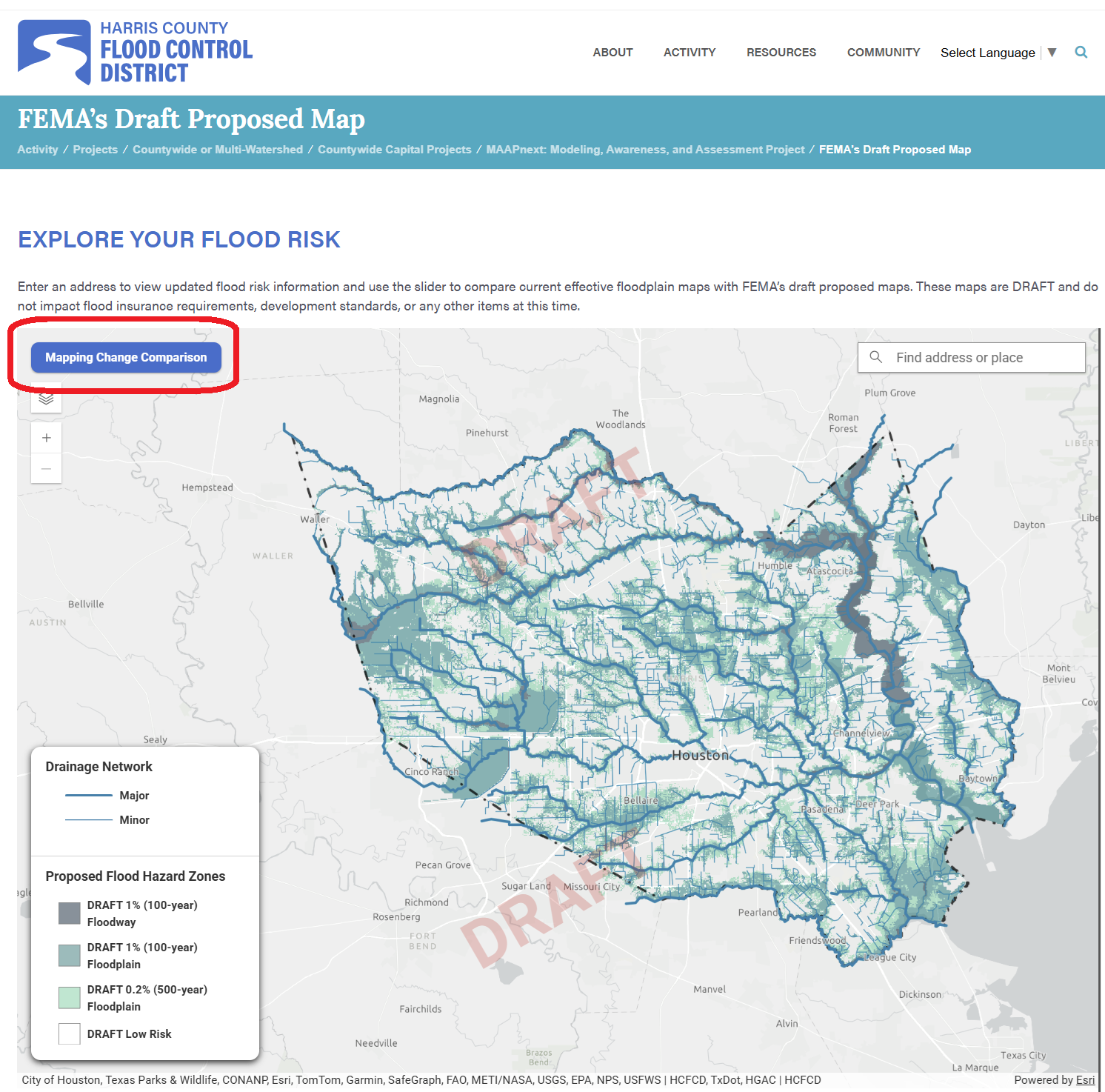
The maps designate areas within the 100- and 500-year floodplains — that is, those properties that have a 1% and a 0.2% of flooding in any given year. When you are looking at the FEMA maps, the 100-year floodplain is designated as “AE.”
The changes primarily reflect updated rainfall projections for southeast Texas adopted by NOAA in 2018 – widely known as “Atlas 14.” These models predict about a 25%-30% increase in rainfall in our region.
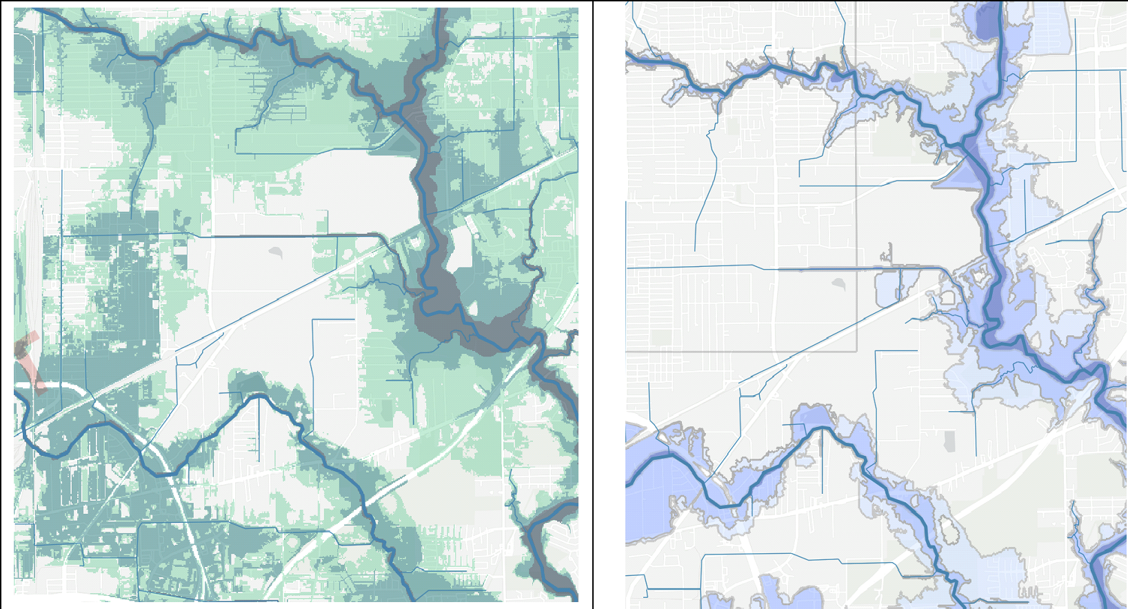
The new maps also reflect changes to the physical watershed, such as additional runoff from paved areas and improvements such as detention facilities. One silver lining of the new maps is that some areas have been removed from the floodplains due to the massive drainage projects completed in those watersheds. These included significant areas near Braes, Sims, Hunting, and White Oak. A particularly dramatic example of this is along Hunting Bayou near the NE corner of Loop 610, where hundreds of homes and businesses have been removed from the floodplain altogether. This includes virtually all of the Settegast neighborhood.
There are two immediate consequences of these changes. First, in nearly all cases, flood insurance will be required to obtain a mortgage on any property that has been moved into a 100-year flood plain. Second, any property moved into a 500-year floodplain will be subject to the regulations adopted by Harris County and the City of Houston after Hurricane Harvey. Generally speaking, these regulations require that any structure in a 500-year floodplain be raised to two feet above what is referred to as the “base flood elevation.” The base flood elevation must be calculated for each property.
While the new flood maps will mean that fewer homes and businesses will flood in future storms, they will also make it dramatically more expensive and difficult to build in Harris County. They will likely make it impractical to build in much of the County. That will, of course, encourage more development outside the County. In a perverse irony, much of the development will be shifted to Montgomery County, where the FEMA maps have not been updated. But of course, drainage from developments in Montgomery County mostly flows downstream into Harris County — once again making the case for a regional flood control authority.
The maps will also cause additional brand damage to the Houston region. They will once again remind individuals and companies considering relocating here of our region’s vulnerability to flooding.
The new maps also underscore the importance of the Harris County Flood Control Authority's timely completion of the 2018 bond program. The completion of those projects could serve as the basis for removing large tracts from the floodplains. The reductions in the floodplain along several of our watersheds show these projects can make a difference.
Building a giant metropolis on a flat coastal plain, subject to frequent hurricanes, reminds me of Robert Burns' line in To a Mouse, “the best laid schemes of mice and men gang aft agley (often go astray).”
Yet perhaps we need to think about our excess rainfall differently and not purely as a liability. In a nation increasingly concerned about freshwater scarcity, Houston’s hydrologic surplus could be a long-term strategic asset. Each inch of rain across Harris County represents roughly 29 billion gallons of freshwater. The challenge is not how to make it disappear faster, but how to capture, store, and recharge more of it. With smarter regional detention, aquifer recharge strategies, and reservoir management, Houston could convert its principal liability into a strategic asset, indeed, perhaps an entirely new industry.
.png)